I just kept looking at Babel Tower, knowing that there was a Class II/III route to the top that we weren't seeing. I did not want to have devoted the day to driving up there and hiking to the peak just to return home without having bagged it. It was only about fifty or so vertical feet of mountain, but it was the difference of having reached the summit, or failure.
Since Andy was really bushed from our previous attempts to get to the top, and he was not as into bagging the summit like I was, he stayed where we had lunch while I went to look one more time to see if we missed something. (I knew we had.)
Climbing back up a trail that I could tell others had used, I went to the point where we had initially looked and had retreated when it looked like a sheer drop off. This time I pushed some low branches aside that were blocking the view, and realized that the trail did not come to an end, but in fact continued around the mountain on a wide ledge. Stepping out on it a few strides, I could see a well-traveled path that led right up through the rocks to the top!
As quickly as I safely could (it was still something of a scramble), I got to the top of the Tower as fast as I could so that I could call down to Andy. He heard me, looked up and waved. But he wasn't keen to join me and was content to wait while I took photos.
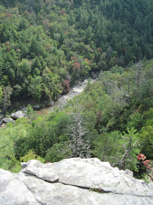
I'm glad I was persistent and found the route to the top. The views from there were quite good, and it was a rewarding experience to peer down on the hairpin curve in the river, Babel Tower standing watch over that terrific bend in the waterway.
Keep on keepin' on, as my dad used to say.
 They don't call it a wilderness area for nothing. This trail was built by the Civilian Conservation Corps back in the 1930s, and it's still a good one.
 After 3+ mile round trip hike (plus much climbing and scrambling at Babel Tower), we approach the parking area where we'd left the truck. It was time to head back home.


No comments:
Post a Comment