Easily the most spectacular of them was Red Fork Falls. It's really easy to find and reach as far as walking distance (only about one mile of hiking, round trip!). But it's not easy to get to when it comes to physical difficulty. To really see the falls you have to climb down a near-vertical face of rock and trees to get to a vantage point. And I didn't even climb all the way to the very base since I'd left Carole at the top of the falls and didn't want to leave her there in the darkening forest too long. The trip down to see these spectacular falls is a Class III scramble. You have to be very careful. I don't think the place suffers too many fools--there's more than ample opportunity for idiots to get killed at this place.
One sad note is that a lot of the trees that visitors use for support on the climbs to the base of the falls and back up are hemlock trees. Surprisingly to me, most of them are still alive--for some reason this area is still in about the mid-phase of the hemlock wooly adelgid infestation--but within two to three years I predict all of the hemlocks here will be dead. If some enterprising local wants to do a good deed, I would suggest buying some Safari-brand adelgicide and hiking in and treating the groves of hemlock trees above, along, and below the falls. That way you'll have these great trees for many decades to come. The option is what has already happened here in North Carolina and Virginia--total loss of all hemlock trees.
Oh, well.
If you get a chance to see these falls, I heartily suggest the minor effort. They're very easy to locate off of the Unaka Mountain Road. The trailhead is marked with a large red dot painting at a small parking area on the right on the paved section of the road before it goes to gravel.
 Walking down the old logging road, you come to some great campsites and then this stream crossing obviously improved by the locals. Cross here and find more great campsites on the other side. Then go straight across and ford the next branch of the creek. Do not head to the left which may seem to be the way. That trail, although well trod, only leads to more campsites and not the falls.
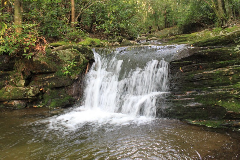 Soon after descending the rough trail a bit, you come to this cascade. It's nice and is actually about five feet high. I left Carole here, since I didn't feel that it would have been safe for her to proceed any farther down the very steep and rugged trail.
 This is where the trail begins to become steeper and more rugged. I turned and took this shot of the way I'd be heading back up.
 The first sight you have of the main section of Red Fork Falls is through the rhododendron along the cliff face. I kept well clear of the water's edge, as it appeared to be quite slick. A fall here would probably be fatal.
 This is an unofficial trail, but pretty logical and well maintained in a weird sort of way. This spot was much steeper than it looks here and was basically a ladder that one downclimbs.
 Another indication of the trail conditions. This is one of the more "level" sections leading down to the best view of the main drop of the waterfall.
 And here I finally was at the small plunge pool at the base of the first big drop of Red Fork Falls.
 And here are the falls, sans human being.
 Red Fork Falls shot from mid-point.
Directions here are taken from the excellent Appalachian Treks website:
From I-26 take the Unicoi exit (#32). At the end of exit ramp turn east towards town. At the stop sign, turn right onto Unicoi Road (which is also known locally as the Erwin Highway) and proceed for 0.7 miles. Follow the signs pointing to the Cherokee National Forest by turning left onto Rt. 107 (Limestone Cove Road). Drive 7.8 miles, turn right on Red Fork Road (it's also referred to as Unaka Mountain Road). Proceed up the mountain for 1.2 miles to a small parking area and trail head to your right -- marked only with a big red dot on one of the trees. After a short walk down the initial part of the trail, you'll cross the creek, then turning right, you'll cross another one. Continue a short ways more and your near-vertical descent will commence!
From I-26 take the Unicoi exit (#32). At the end of exit ramp turn east towards town. At the stop sign, turn right onto Unicoi Road (which is also known locally as the Erwin Highway) and proceed for 0.7 miles. Follow the signs pointing to the Cherokee National Forest by turning left onto Rt. 107 (Limestone Cove Road). Drive 7.8 miles, turn right on Red Fork Road (it's also referred to as Unaka Mountain Road). Proceed up the mountain for 1.2 miles to a small parking area and trail head to your right -- marked only with a big red dot on one of the trees. After a short walk down the initial part of the trail, you'll cross the creek, then turning right, you'll cross another one. Continue a short ways more and your near-vertical descent will commence!
No comments:
Post a Comment