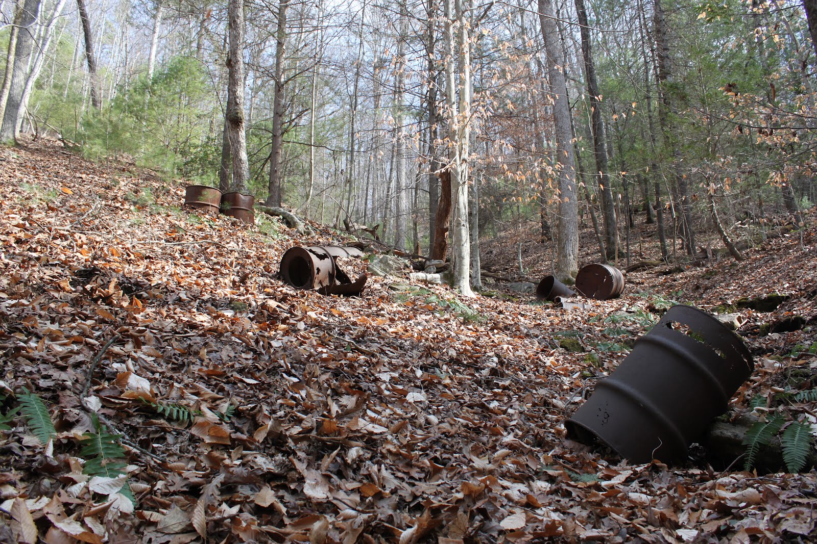
More often than I would think, my hiking pals and I stumble upon old, abandoned whiskey stills when we're bushwhacking through the mountains looking for new waterfalls or trying to find our ways to the tops of isolated summits that don't have trails.
Last winter, on a hike to find the elusive Sally Queen Falls, we stumbled upon just such an abandoned still. This one looked to have been last used many, many years ago. These mountains are full of old roads that were probably passable as late as the early 1960s, but which are now not even recognizable as road beds.
The still here was probably pretty high volume, so they'd have needed road access to be nearby, even if they were able to haul out gallons of this stuff by hand or by pack horse.
Anyway, the southern Appalachians are packed with these old sites.
Showing posts with label South Mountains Game Land. Show all posts
Showing posts with label South Mountains Game Land. Show all posts
Wednesday, February 22, 2012


Friday, March 11, 2011
A Brief Commentary on Bushwhacking
I'm a tenacious peak-bagger. There's nothing I like better than hiking to the top of a named summit and standing on the highest point. Even if it's just an old, rounded, eroded mountain peak that's generally unremarkable I get a kick out of finding the top-most bit of real estate and hiking to the very highest elevation.
When you have occasion to bushwhack to a mountaintop, one comes to appreciate the labor, engineering, and effort that it took to create a graded trail to the top. And that, of course, is the easiest (and best) way to reach a summit--by hiking an official and well maintained trail. Bushwhacking is a lot of fun, too, but it tires you out not just physically, but also mentally. And there are ways to wear down your emotions as well as your muscles. Hiking cross country in the tortured landscape of a southern mountain is just one way to do this.
On our hike to find Sally Queen Falls we discovered that despite the fact that they South Mountains aren't really very high in terms of mean sea level, they are a stupendously rugged chunk of real estate. The hike took place in winter when the leaves are off the trees and it's easy to see through the forest. And although it was unseasonably warm that day, we didn't have to deal with much in the way of foot-snagging brush, nor blood-sucking crawling things like mosquitoes, gnats, deer flies, and ticks. Nor did we have to worry about snakes. If I ever bushwhack in the South Mountains, it will have to be in the colder months when conditions are against the bugs and thorns.
Following are some random photos that I took which, I hope, can convey the toughness of the hike we took to find Sally Queen Falls.
 This is the actual summit of Richland Mountain. Now, normally I would have jumped at the chance to jog up this last bit of distance to the very top. But I was so exhausted after our day of hiking that it was the easiest thing in the world to just sit there in the leaves and look up at the summit and decide that it could wait for another day. So, technically speaking, I did not climb to the top of Richland Mountain.
 You make your own trails when you go bushwhacking. You have to constantly stop and survey the territory and decide where your next step is going to go and what you should do to avoid trouble ahead.
 Jack and Andy press on while I lag back to take some photos.
 Jack has already crossed a deep gully while Andy follows (Boone getting ready to go over the downed tree). You can't just bull straight ahead when bushwhacking.
 I paused at one point after descending Richland Mountain to look back up the way we'd come. The peak might not be even 2800 feet high, but it's one very steep mountain.
 For some reason I didn't take any photos while we were negotiating our way through that huge and monstrous rhododendron hell. But I did find that I'd taken one shot as we entered a small patch of such shrubs.
 As I said, the slopes of the South Mountains are indeed steep and extremely rugged.
 But you know what? There are great treasures often to be found off the beaten path and away from the marked and developed trails. Sally Queen Falls was worth the effort.
When you have occasion to bushwhack to a mountaintop, one comes to appreciate the labor, engineering, and effort that it took to create a graded trail to the top. And that, of course, is the easiest (and best) way to reach a summit--by hiking an official and well maintained trail. Bushwhacking is a lot of fun, too, but it tires you out not just physically, but also mentally. And there are ways to wear down your emotions as well as your muscles. Hiking cross country in the tortured landscape of a southern mountain is just one way to do this.
On our hike to find Sally Queen Falls we discovered that despite the fact that they South Mountains aren't really very high in terms of mean sea level, they are a stupendously rugged chunk of real estate. The hike took place in winter when the leaves are off the trees and it's easy to see through the forest. And although it was unseasonably warm that day, we didn't have to deal with much in the way of foot-snagging brush, nor blood-sucking crawling things like mosquitoes, gnats, deer flies, and ticks. Nor did we have to worry about snakes. If I ever bushwhack in the South Mountains, it will have to be in the colder months when conditions are against the bugs and thorns.
Following are some random photos that I took which, I hope, can convey the toughness of the hike we took to find Sally Queen Falls.
 This is the actual summit of Richland Mountain. Now, normally I would have jumped at the chance to jog up this last bit of distance to the very top. But I was so exhausted after our day of hiking that it was the easiest thing in the world to just sit there in the leaves and look up at the summit and decide that it could wait for another day. So, technically speaking, I did not climb to the top of Richland Mountain.
 You make your own trails when you go bushwhacking. You have to constantly stop and survey the territory and decide where your next step is going to go and what you should do to avoid trouble ahead.
 Jack and Andy press on while I lag back to take some photos.
  Jack has already crossed a deep gully while Andy follows (Boone getting ready to go over the downed tree). You can't just bull straight ahead when bushwhacking.
 I paused at one point after descending Richland Mountain to look back up the way we'd come. The peak might not be even 2800 feet high, but it's one very steep mountain.
 For some reason I didn't take any photos while we were negotiating our way through that huge and monstrous rhododendron hell. But I did find that I'd taken one shot as we entered a small patch of such shrubs.
 As I said, the slopes of the South Mountains are indeed steep and extremely rugged.
 But you know what? There are great treasures often to be found off the beaten path and away from the marked and developed trails. Sally Queen Falls was worth the effort.
Thursday, March 03, 2011
Random Images
Following are just some random photographs that I took on the hike to find Sally Queen Falls. In most cases they need no further delineations, but I'll write details anyway.
 Sally Queen Falls itself. We were not expecting quite so spectacular a sight.
 This was the first unblocked view we got of the falls as we came down the track we were using.
 Sally Queen Creek is really a pristine waterway. Here Boone checks it out.
 Jack and Andy kept us on an accurate track throughout the hike.
 The impressive field of broom sedge where we came out of the forest.
 This is the abandoned moonshine still that we stumbled upon. Great location with its own pure spring which you can see Boone sampling.
 This old forest giant had lost its grip on the creek bank and had toppled over, forming an excellent bridge. The tree was so big and wide and had so recently fallen (no more than a couple of weeks, I'd wager) that I felt perfectly safe walking to the middle to take photographs of Sally Queen Creek from the vantage point. (Photo by Jack Thyen).
 My view from the middle of the tree trunk.
 Looking down in the other direction.
Video taken from beside Sally Queen Falls.
Buy my new zombie novel THE LIVING END!
and my previous eco-thriller THE FLOCK (optioned by Warner Brothers!).
 Sally Queen Falls itself. We were not expecting quite so spectacular a sight.
 This was the first unblocked view we got of the falls as we came down the track we were using.
 Sally Queen Creek is really a pristine waterway. Here Boone checks it out.
 Jack and Andy kept us on an accurate track throughout the hike.
 The impressive field of broom sedge where we came out of the forest.
 This is the abandoned moonshine still that we stumbled upon. Great location with its own pure spring which you can see Boone sampling.
 This old forest giant had lost its grip on the creek bank and had toppled over, forming an excellent bridge. The tree was so big and wide and had so recently fallen (no more than a couple of weeks, I'd wager) that I felt perfectly safe walking to the middle to take photographs of Sally Queen Creek from the vantage point. (Photo by Jack Thyen).
 My view from the middle of the tree trunk.
  Looking down in the other direction.
 Video taken from beside Sally Queen Falls.
Buy my new zombie novel THE LIVING END!
and my previous eco-thriller THE FLOCK (optioned by Warner Brothers!).
Wednesday, March 02, 2011
'Shwackin' the Southies
Andy Kunkle and Jack Thyen did all of the work of plotting out a course for our bushwhack into the South Mountains Game Lands. What we wanted to do was find a rumored waterfall that is located somewhere in the Game Lands on a stream called Sally Queen Creek. What we were pretty sure about was that the falls existed, but not exactly where it was or whether it was even worth the labor of finding it. But, every good hike is worth doing, even if you don't achieve your main goal.
I'm glad that Andy has had a fair amount of experience in orienteering. I'm not that good at it and just know the basics. One thing that I do know is that when traveling off trail you should stop relatively often to take compass readings, observe landmarks, and double-check to make sure that you're on the right bearing. After a while we were so comfortable moving along and enjoying the forest that we neglected to check our maps as often as we should. Thus, we ended up several degrees off target and came out onto Sally Queen Creek a good chunk of distance south of where we should have been.
That's okay, though, because if not for that slight miscalculation we would have missed seeing several small stands of impressive trees, and an abandoned whiskey still. On the bad side, we wandered off of the Game Lands and onto a dirt road that was definitely on private property. Here in the South, private property is a serious business, and if it's posted "no trespassing", then it means what it says. But we were kind of stuck out in the track for a bit and decided to just push ahead until we veered back into the Game Lands. I, of course, being the only native Southerner in the trio, pushed on at some speed to get my ass the hell off of the posted property and back onto public land. This we did in quick order, following the meandering rush of Sally Queen Creek.
The watershed of the South Mountains is considered one of the cleanest in the eastern USA. And I believe it. There is no development at all in this watershed, beside some clear cutting in some parts of the forest outside of the South Mountains State Park boundary. Other than that, there's nothing at all to foul the watershed. It's just a huge area devoid of any kind of industry or permanent human habitation.
We continued to make pretty good time and were soon within what I can only call a small gorge. The slopes on both sides of Sally Queen Creek became very precipitous, with small cliff faces on both shores. The major tree species along this part of the forest were white pines, eastern and carolina hemlocks, oaks, and beeches. We actually saw quite a number of beech trees. Sadly, the hemlocks are all dead or dying and all of the really big hemlocks have given up the ghost. Hemlock wooly adelgid has dealt a mortal blow on South Mountains' hemlock groves. Some really big old hemlocks in here are no more.
We kept our eyes peeled for the falls that we were expecting to see. But we didn't know what they'd look like. Would it be merely a small set of cascades? Would it be a single drop of ten feet or so? Would the volume of the falls be small or heavy? We just didn't have any information at all about such details. But we kept looking ahead, sometimes dropping down from the old narrow gauge railway bed that was our trail to see if the falls were on the creek below.
And then, suddenly, on the waterway ahead of us, we saw them: Sally Queen Falls. And we realized at once that seeing them was worth every bit of the effort involved in getting there. The water flow was very good, despite the fact that we're in a minor drought just now. The falls drops about twenty-five to thirty feet in two main levels. There's a sharper and shorter initial drop into a pool, and then a slanting falls higher and of greater distance than the first just below. We were all very impressed. We'd located a North Carolina waterfall that few others know about and which are very difficult to access. This place will certainly never be a crowded location.
We spent about an hour here. We opened our packs and ate lunch, drank water, and took dozens of photographs between us. Eventually, though, we decided that it was time to head back. We knew that we'd have to alter our return route so that we wouldn't veer off onto any more private property. Jack and Andy consulted the maps again and we crossed Sally Queen Creek at an old narrow gauge railroad bed that we'd spotted about a quarter of a mile back down the quasi-trail that we'd used. Taking that, we began to climb up the slopes of Richland Mountain, heading back in a direction that we hoped would slab us along the steep slopes, taking us over a high gap and then down the mountain to a spot on the road that we hoped would be near Andy's car.
The going was pretty tough. You can say what you want about the South Mountains not being particularly high, but they are certainly steep and rugged. The hillsides are also packed with good forest cover, but the toughest thing we did was hike about half a mile directly through a rhododendron thicket. The mountaineers called these thickets "hells", and there's a good reason for that. Trying to hike through them is like trying to negotiate through a hellish maze. I don't recommend it.
Eventually, we made the gap near the top of Richland Mountain and took another good break, taking time to rest and to drink water and just take it easy for a bit. But soon it was time to head out again, this time directly downhill. In a while we came to the bottom of the mountain and found ourselves at the edge of a very large field of broom sedge. We crossed this and came out on the road. Looking to our right, we found that we'd hit the road no more than a hundred yards or so from the car! Andy and Jack couldn't have done a better job of orienteering! My hat's off to the both of them!
 Andy and Jack (and Boone) stand beside a nice white pine on our way into the Game Lands.
 This was a very nice Tulip poplar that I spotted along the way. I had to scramble up the slope to take a self-portrait. The tortured root system of this tree was amazing--the tenacity of hanging on to the steep sides of the mountain!
 This gives you an idea of the steepness of the mountainside we had to hike.
 Nearing the falls, the sides of the mountains become a small gorge.
Not long before we reached the falls, we spotted a huge tree that had just recently fallen across the creek, bridging the sides. Of course I had to hike out onto it and take some photos and video.
 And here I am at Sally Queen Falls, a place you will likely never see.
 Sally Queen Falls.
Nice video of the falls in action.
 Falls framed by rock and trees.
 Andy took this one of me at the falls just before we headed out.
 Another one by Andy Kunkle, this one of me hiking through the field of broom sedge.
 Jack created this image of the route we hiked. We started at the blue dot at the bottom of the map, headed toward the left to the blue dot at the upper part of the map (the falls), the across Richland Mountain back to the car. Not sure how many miles, but a very tough hike indeed.
Buy my first novel THE FLOCK!
Buy my latest book THE LIVING END: A Zombie Novel!!!
I'm glad that Andy has had a fair amount of experience in orienteering. I'm not that good at it and just know the basics. One thing that I do know is that when traveling off trail you should stop relatively often to take compass readings, observe landmarks, and double-check to make sure that you're on the right bearing. After a while we were so comfortable moving along and enjoying the forest that we neglected to check our maps as often as we should. Thus, we ended up several degrees off target and came out onto Sally Queen Creek a good chunk of distance south of where we should have been.
That's okay, though, because if not for that slight miscalculation we would have missed seeing several small stands of impressive trees, and an abandoned whiskey still. On the bad side, we wandered off of the Game Lands and onto a dirt road that was definitely on private property. Here in the South, private property is a serious business, and if it's posted "no trespassing", then it means what it says. But we were kind of stuck out in the track for a bit and decided to just push ahead until we veered back into the Game Lands. I, of course, being the only native Southerner in the trio, pushed on at some speed to get my ass the hell off of the posted property and back onto public land. This we did in quick order, following the meandering rush of Sally Queen Creek.
The watershed of the South Mountains is considered one of the cleanest in the eastern USA. And I believe it. There is no development at all in this watershed, beside some clear cutting in some parts of the forest outside of the South Mountains State Park boundary. Other than that, there's nothing at all to foul the watershed. It's just a huge area devoid of any kind of industry or permanent human habitation.
We continued to make pretty good time and were soon within what I can only call a small gorge. The slopes on both sides of Sally Queen Creek became very precipitous, with small cliff faces on both shores. The major tree species along this part of the forest were white pines, eastern and carolina hemlocks, oaks, and beeches. We actually saw quite a number of beech trees. Sadly, the hemlocks are all dead or dying and all of the really big hemlocks have given up the ghost. Hemlock wooly adelgid has dealt a mortal blow on South Mountains' hemlock groves. Some really big old hemlocks in here are no more.
We kept our eyes peeled for the falls that we were expecting to see. But we didn't know what they'd look like. Would it be merely a small set of cascades? Would it be a single drop of ten feet or so? Would the volume of the falls be small or heavy? We just didn't have any information at all about such details. But we kept looking ahead, sometimes dropping down from the old narrow gauge railway bed that was our trail to see if the falls were on the creek below.
And then, suddenly, on the waterway ahead of us, we saw them: Sally Queen Falls. And we realized at once that seeing them was worth every bit of the effort involved in getting there. The water flow was very good, despite the fact that we're in a minor drought just now. The falls drops about twenty-five to thirty feet in two main levels. There's a sharper and shorter initial drop into a pool, and then a slanting falls higher and of greater distance than the first just below. We were all very impressed. We'd located a North Carolina waterfall that few others know about and which are very difficult to access. This place will certainly never be a crowded location.
We spent about an hour here. We opened our packs and ate lunch, drank water, and took dozens of photographs between us. Eventually, though, we decided that it was time to head back. We knew that we'd have to alter our return route so that we wouldn't veer off onto any more private property. Jack and Andy consulted the maps again and we crossed Sally Queen Creek at an old narrow gauge railroad bed that we'd spotted about a quarter of a mile back down the quasi-trail that we'd used. Taking that, we began to climb up the slopes of Richland Mountain, heading back in a direction that we hoped would slab us along the steep slopes, taking us over a high gap and then down the mountain to a spot on the road that we hoped would be near Andy's car.
The going was pretty tough. You can say what you want about the South Mountains not being particularly high, but they are certainly steep and rugged. The hillsides are also packed with good forest cover, but the toughest thing we did was hike about half a mile directly through a rhododendron thicket. The mountaineers called these thickets "hells", and there's a good reason for that. Trying to hike through them is like trying to negotiate through a hellish maze. I don't recommend it.
Eventually, we made the gap near the top of Richland Mountain and took another good break, taking time to rest and to drink water and just take it easy for a bit. But soon it was time to head out again, this time directly downhill. In a while we came to the bottom of the mountain and found ourselves at the edge of a very large field of broom sedge. We crossed this and came out on the road. Looking to our right, we found that we'd hit the road no more than a hundred yards or so from the car! Andy and Jack couldn't have done a better job of orienteering! My hat's off to the both of them!
 Andy and Jack (and Boone) stand beside a nice white pine on our way into the Game Lands.
 This was a very nice Tulip poplar that I spotted along the way. I had to scramble up the slope to take a self-portrait. The tortured root system of this tree was amazing--the tenacity of hanging on to the steep sides of the mountain!
 This gives you an idea of the steepness of the mountainside we had to hike.
  Nearing the falls, the sides of the mountains become a small gorge.
 And here I am at Sally Queen Falls, a place you will likely never see.
 Sally Queen Falls.
 Nice video of the falls in action.
 Falls framed by rock and trees.
  Andy took this one of me at the falls just before we headed out.
  Another one by Andy Kunkle, this one of me hiking through the field of broom sedge.
 Jack created this image of the route we hiked. We started at the blue dot at the bottom of the map, headed toward the left to the blue dot at the upper part of the map (the falls), the across Richland Mountain back to the car. Not sure how many miles, but a very tough hike indeed.
Buy my first novel THE FLOCK!
Buy my latest book THE LIVING END: A Zombie Novel!!!
Monday, February 28, 2011
Sally Queen Falls
Today (Sunday, 02-27-2011) Jack Thyen, Andy Kunkle (and Boone the dawg) and I went on a long bushwhack into the South Mountains Games Lands. We took this hike to try to find a waterfall that was rumored to be located on a stream in the game lands not far from the South Mountains State Park. Jack and Andy did the orienteering and I followed. Tomorrow I'll try to write more about the hellis...hike. This was one of the toughest hikes I've been on in a very long time. We pretty much bushwhacked the entire way, for we had to carefully stay on public land, off of posted private property, and without a single official trail to follow.
We found the waterfall and discovered that it's not a rumor. It was well worth the very long, very tough hike in and out of the area.
Until later, here are a couple of photos:
 We even stumbled upon some nice old trees. This poplar was fairly impressive.
 Here I am, in self-portrait, at the former mystery of Sally Queen Falls.
Buy THE LIVING END...
and THE FLOCK!
We found the waterfall and discovered that it's not a rumor. It was well worth the very long, very tough hike in and out of the area.
Until later, here are a couple of photos:
 We even stumbled upon some nice old trees. This poplar was fairly impressive.
 Here I am, in self-portrait, at the former mystery of Sally Queen Falls.
Buy THE LIVING END...
and THE FLOCK!
Tuesday, February 08, 2011
Clear Cut
During our hike to find the summit of Buzzard Roost, we had to hike through the South Mountains Wildlife Refuge. Now, most people think of preservation when they hear a term like "wildlife refuge". Nothing could be further from the truth. What the term means is that the area is closed to some minor types of development, but open to regulated hunting. Things such as access roads and logging and even mining are allowed in such places.
In the case of our hike, we had to walk through an extensive clear cut. Some types of wildlife enjoy a temporary population increase in places where the forests have been totally felled to the bare earth. Shrubs and weeds offer browse for rabbits, deer, turkey, grouse, and some other forms of game. But it wrecks the forest and ruins the forest ecosystem that existed before the clear cut.
Here, then, are a few photos of our hike through the South Mountains Game Land clear cut.


 Staging area for heavy equipment.
 I don't even want to think of what hiking this area would be like in summer.
Subscribe to:
Posts (Atom)