Friday, October 21, 2011

Dolly Sods, Part I

I decided after a bit of deliberation to take a hike into the Dolly Sods Wilderness. Carole and I had been there once before, but I didn't get to hike much on that trip. And it was in the summertime. Also, I wanted to bag at least one named peak in the wilderness and picked out the one I wanted from my map of Dolly Sods. Decision made, I left Carole at the Seneca Shadows Campground one fine, bright morning and headed off on my own to do some dayhiking.

I arrived at Dolly Sods early after a 30-minute drive from the Seneca Shadows Campground where we were staying. It was good to get an early start. The wilderness was fairly crowded around the Forest Service access road, but mainly with the parked cars of backpackers who were all well into the wilderness from the day before.

I parked at the Blackbird Knob trailhead and pushed on into the wilderness, my main goal of the hike to find and bushwhack to the summit of Blackbird Knob.


One of the roadside signs marking a border of the Dolly Sods Wilderness Area.

This sign is serious. Back in the day, the Sods were a major firing range for the US military. Many rounds were fired here because the land was so open. However, lots of mortars landed and did not detonate and merely buried themselves in the often soft muck on the terrain. And to this day they sometimes emerge from the earth, some of them still live. If you see one, mark its location and back away. DO NOT TOUCH them! They can go off.

The first part of the trail is a boardwalk that crosses a very boggy area. Boggy areas are common in Dolly Sods which is one of the highest large valleys in the eastern United States.

Newly fallen birch leaves on the trail.

Vistas are almost always near at hand. This one was on a side trail that bypasses the main trail and heads upslope.

I'd seen photos of this campsite on the Internet and recognized it immediately. Some enterprising backpackers had made some serviceable chairs out of flat stones here.

There are lots of talus fields in the Sods.

Just because something looks like a trail doesn't necessarily make it one. It's easy to go off route if you don't pay attention out in this open country.

I've been in Dolly Sods Wilderness in summer and now in Fall. I think I prefer the Fall. It just makes for striking scenery in every direction when you have this kind of color all around you.

This photo doesn't convey it very well, but the trail was pretty much nothing but swamp and stream. The area had received quite a lot of rainfall the previous three days, and so it was like marching in muck most of the time.

This temporary pond was beside the trail in a particularly boggy area.

Some of the creeks have a red tint to them from the influence of tannins in the soil from the drop of thousands of years worth of evergreen needles.

At last, I find Blackbird Knob and begin to buswhack off trail toward the summit.

The broad summit area of Blackbird Knob. The views were so gorgeous that I literally stood around whooping. Who the hell cared? I was alone and full of joy.

The wind was horrible on the top. I managed to get a few self-portraits with my camera and tripod, but later a really vicious gust of wind knocked the whole thing down and so I packed the tripod away.

There go my ideas that no one else had ever been here. I found this old campsite situated behind some spruce trees.

I didn't know what these were. Little mounds here and there in open areas. Later, my go-to guys for all things natural told me that they were anthills. I'd poked them to see if any ants would emerge, but none did. Probably all dormant by this time of year.

And just before I got back to the Red Creek Campground area, I turned around to snap a parting shot on the Blackbird Knob Trail. Now I was ready to head over to the Bear Rocks area and see what I could find.

Part II tomorrow...

Thursday, October 20, 2011

Kumbrabow State Forest

Our original plans for this trip were to stay first at Holly River State Park. When we called to get reservations there, we were told that they don't take reservations after Labor Day, but that "the park campground NEVER fills up after Labor Day". We were further told that if we came up we were guaranteed a campsite.


As soon as we pulled in to the park we realized that the woman in the park office was full of shit. The park was packed to the gills with humans. Every campsite had at least one trailer and multiple tent/trailer combinations on it. The park roads were crammed with people. It was like being in a crowded city. Apparently the park was having a festival, which had been in the planning stages for over a year, and which the park personnel were all aware of, knowing that there would be no room for overflow in the campgrounds.

Fortunately, we were prepared for this. Ignoring the advice of the Holly River State Park Moron, we had brought our generator along and had filled our fresh water tank back in Charlotte. So we didn't need a site with hookups and headed over to Kumbrabow State Forest where there were rustic sites available. We only hoped we weren't too late to snag a good campsite.

As it turned out, the locals all wanted campsites with power hookups, and so we found Kumbrabow pretty much vacant. Which is exactly what we were searching for. Isolation, peace, and quiet. In addition, the park ranger at Kumbrabow turned out to be the nicest, friendliest, most helpful park ranger we've ever met. I've misplaced his name, but if you stay there, you're going to be well taken care of because of this fellow.

As everything turned out, the best part of our trip was our stay at Kumbrabow. We'll go back, for sure. The park is really large, and has a good system of trails and is close to other areas for outdoor activities.

This was our campsite at Kumbrabow State Forest. We didn't set up our other canopy because the weather was so nice.

The playground in the center of the campground. One other family arrived to stay a couple of nights and their kids loved the playground.

The trail right behind our trailer leading down to the creek.

The creek which lulled us to sleep every night.

Looking down stream.

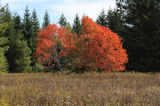
This brilliantly colored tree was growing in a field which is all that remains of the CCC camp that housed the workers who built the infrastructure of the park which is all still in use today. The camp is now only this field and a few rusting bits of girders that were once part of the barracks and other housing for the workers.

Mill Creek Falls. This is one of the most photogenic waterfalls I've ever seen, and I love to visit it. Both times I've been I haven't bee able to swim there because it's always been too cold. You can rent the cabin visible through the trees. The cabins here are rather rustic. Lighting and refrigeration and heating are by gas. There are no showers in them. There are central vault toilets and for hot showers you have to drive to the park office complex up the road. Built by the CCC boys back when socialism wasn't a dirty word.

A little forest of mushrooms growing on a dead tree beside Mill Creek Falls.

This was as close as we came to seeing a raccoon on this trip. Just some fresh tracks near the waterfall.

The cabin just beside Mill Creek Falls. There are, I think, six cabins in this complex. All built by the CCC.


Mill Creek Falls.


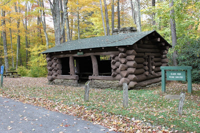
A picnic shelter in the park.

Inside the shelter. We could put unemployed engineers, architects, and laborers to work today constructing park infrastructure if we weren't ruled over by filthy corporations and their lackeys.

Behind the shelter. I took this one because I liked the patterns and colors of the fallen leaves against the angles of the building.

Carole, peeking out of the shelter window.

This culvert bridge cuts the campground in half. Sites on either side of the creek.

Another shot of the creek. I took this one the night before we left.

And one of the more tent-friendly campsites at Kumbrabow. Ours did not have the little fireplace.

Wednesday, October 19, 2011

Brilliant Fall Colors

As soon as we arrived at our first campsite in Kumbrabow State Forest Carole and I realized that we'd hit the Fall colors at their utmost peak. And we lucked out even more than that. It was also obvious to us that these were the most brilliant colors that Autumn had delivered to our eyes in decades. I can't recall colors so bright and pleasing since the year after I graduated from high school. It was magic.

Here, then, are some of Mother Nature's sleights of hand:
From the Raven Rocks overlook.

On the road through Kumbrabow State Forest.

Another view from Raven Rocks.

On one of the high trails through the park. I was closing in on the 4,000-foot mark when I looked up and snapped this shot.

This bit of beauty was located at the remains of the old CCC camp that housed the men who put this park together.

One rainy day we drove into the high peaks region. The rains were heavy and slowly knocking down the brilliantly hued leaves from the hardwoods. I stopped along a lonely Forest Service road and got this view.

Afternoon sun accentuates the already bright Autumn colors of the slopes beyond Seneca Rocks. Yet another treasure from our campsite at Seneca Shadows.


A lonely hike along the mountain ridge.

Tuesday, October 18, 2011

The Osage Orange

An Osage orange I picked up along the upper reaches of the Potomac River and brought home. It has a most pleasing scent.

While Carole and I were exploring the Smokehole Canyon in West Virginia, I happened to see an Osage orange tree growing along the banks of a branch of the Potomac River. The tree had dropped ripe fruit into that river, perhaps aiding in spreading the seeds downstream.

And this reminded me of the fate of that tree.

The Osage orange is native to parts of Texas and Arkansas and Oklahoma. It does grow in other parts of North America due to it being planted by Europeans. I recall seeing them from time to time in the woods of my native Georgia where it was known as "the horse apple", because of the fact that horses will sometimes eat the ripe fruit.

The pre-Indian North American horse.

However, from evidence, it was once far more widespread than it is today. This is probably because the "oranges" were a favorite food of several large extinct mammals. Back then, the fruit would go through the digestive systems of these large animals and the seeds would be distributed widely in their travels within their dung. It's figured that such creatures as Mammoths, mastodons, giant sloths, and probably even horses ate Osage oranges and shat the seeds far and wide.

The Imperial mammoth, which likely ate lots of Osage oranges.

Alas, the arrival of humans to North America put an end to most of our continent's megafauna, and so the Osage orange lost its main vectors of distribution.

Today, you see it rarely out of its current range. But at one time it went wherever the big mammals roamed. Mammals that were all killed and eaten up by the vast tribes of the folk we now refer to as the Native Americans.

And now the tree probably best finds distribution via waterways?


(With a tip of the hat to Mark Gelbart's GEORGIA BEFORE PEOPLE.)

Monday, October 17, 2011

The Salamander!

Carole loves to take train rides. We've been on a few one-day jaunts, mainly in the mountains of North Carolina and West Virginia. Since most passenger train service is gone from that area, the only places to enjoy such an experience are where some public/private concerns have taken over short bits of rail lines, paid out the money for the purchase and upkeep of the necessary engines and rail cars, and instituted a tourist ride.


We found one such outfit in Elkins, West Virginia and promptly booked a couple of tickets. The day we went the weather was quite nasty, so we knew we weren't going to get any hiking and picnicking done. The price of the tickets included a buffet lunch, so we didn't even have to pack that. All we had to bring were some spare jackets (for rain), the camera, and a tripod. And off we went!

We took the Salamander, so named because of the endangered Cheat Mountain salamander. So they tagged it onto the official name for the line. The city of Elkins has refurbished the old train station--it's quite pleasant to look at and inside there is a museum, ticket office, information kiosk, a shop, and rest rooms.

We arrived for our ride at 9:30 am, and boarded the train at 10:00 am. After that, we were on our way!


The station in downtown Elkins, WV.

The choo-choo train!

The "green" car, and my sweet wife already making friends with the couple behind us before we can even sit down.

This guy was our guide and entertainment for the ride. He had a lot of cool history and information about our route and the cool stuff along it.

A rough section of whitewater taken through the window along the ride. The water appears "dirty" but in fact this river is one of the ten cleanest in the USA. The color is from tannins produced by tens of thousands of years of the drop of hemlock and spruce needles into the soil.

An abandoned rail bridge and rail line we pass along the way.

The most scenic destination on the ride: The High Falls of the Cheat River. They are called "high" not because of the height of the falls (only about 15 feet), but because they are located so high on the river--about 3,000 feet elevation. Also, they're not technically on the Cheat River, but on the Shavers Fork of the Cheat, which runs into the Cheat River. Because of the heavy rain, the volume of water going over the falls was very impressive.


Below the Falls.

Self-portrait in the rain. The rocks were VERY slick! If you go, be careful! It was really starting to pour down so I had to hurry this shot and get the camera dry.

The falls from above.


Video from above High Falls of the Cheat River.

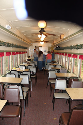
The dining car where we were served sandwiches buffet style. The sandwiches were very good! Lots to drink, too. Tea, water, lemonade, coffee, hot chocolate, etc. And fruit and cookies, also.

These were once for men working on the rail lines. The company would drop them off with a couple of cooks and food and they would work the lines. Later, a train would stop to pick them up. After the line was abandoned, these houses were bought by individuals and are now private. Access is pretty much either by arranging a ride on the Salamander, or hiking in, or getting the Forest Service to unlock a gate on a primitive road. Our guide told us that he sees the owners using these two houses only a few times per year. They are extremely isolated.

The end of the line where the engine detached and reversed the train. It's called The Cheat Bridge.

We all got out to stretch our legs while the engine made its changes.

This is what happens when kids live in an isolated village with a population of 20. This car was stolen by some local teens in Bemis. Really. Only about twenty people live there year-round. The few kids were bored. So they hiked out, found this car, boosted it, drove it around for awhile and then somehow aimed it straight down the mountain and maneuvered it through the forest down a 40-degree slope and crashed it here next to the train track. The final impact set off the airbags. No one has yet been able to figure out how to get it the hell out of its current location. Despite appearances, this is not a road, but just a patch of green out in the middle of nowhere. I assume the insurance folk will just consider it totaled and pay the owners off.

And here is Carole getting off the train as we arrive back in Elkins!