Showing posts with label Glacier. Show all posts

Monday, September 14, 2015

The Iceberg Lake Trail, Part I.

Probably the prettiest hike we took on the trip was the one to Iceberg Lake. It's a pretty darned popular day-hike in the Park, so one is rarely alone on the trail. Also, it's a relatively easy hike of ten miles round-trip with not a lot of climbing. There's a steep section in the first mile, but after that it's petty steady and easy going.

One thing that I can say about this hike is that there is a lot to look at. Some of the route passes through forest, but the lion's share is above tree line and through meadows and open country with limitless views. Since the surrounding peaks loom as vast walls of steep rock, you often feel as though you are in a tremendous amphitheater. This is completely true of the terminus of the hike in the huge glacial bowl where Iceberg Lake is located.

Iceberg Lake was obviously the location of a glacier in recent times. In fact, there's a pretty extensive snowfield that lies just above the lake, hanging on the rocky slopes even late into summer. And the lake is colored with "glacial flour" (finely ground rock) which is produced by glacial action and gives the water a striking emerald hue. In heavy snow years the lake stays full of the icebergs for which it is named, but since there was very low snow in the winter of 2014/15, we arrived to find only two very tiny icebergs floating around on the opposite side of the lake.

Also in normal years, the area is packed with wildlife. I'd been told that it was one of the best areas to see many of the Park's signature creatures. However, 2015 was anything but a normal year for Glacier National Park. We were lucky enough to have pretty clear skies. The forest fires were still holding off the day we made the hike and the air was barely tinged with smoke. It wasn't as clear as the previous day, but almost so.

As for the wildlife, we managed to see a grouse, several types of resident rodents, and a vast herd of Bighorn sheep.

Today I will post photos of the hike from the start until just before we arrived at the Lake.


I had stayed behind at the truck to work on my camera equipment while the others pushed on. So it took me  a while to catch up to them. Here was Andy and Bobby ahead of me as I struggled to find the rest of the group. The air was really clear that day and the views would stop you every few steps.


Scenery to die for.

Vast peaks rising all around us.

We happened upon this grouse. She was speaking to us constantly, or to her two nearly-grown chicks. She seemed very nervous to have us so near her babies, but the pair of youngsters hardly seemed to notice us.

This was the drop-off of a really high waterfall. But it was almost impossible to see it because it plummets into a very narrow chasm. Getting down to a spot where you could take an effective photograph would be difficult at best, and probably very dangerous.

As good a video as I could shoot considering my choices.

We got to a point where we could see ahead to the huge glacial cirque that hold the lake.

Nice shot showing the snowfields above the lake.

I like this shot. Indicative of the rugged terrain through which we were hiking.

And almost to the lake we looked up to see a truly vast herd of Bighorn sheep. The herd seemed to be composed entirely of ewes and lambs. If there were any adult males in there, I didn't see them. This is just a piece of the herd and is a crop of a telephoto shot. Currently I have only one low-quality telephoto lens and it frankly takes grainy photos at distance. When I can, I will purchase a better lens for long shots.

Monday, October 15, 2012

Rock Glacier

As glaciers in the lower 48 are headed to extinction, we are left with remnants of them--formations that are known as "rock glaciers". I was vaguely aware of these things until I read a great article about them on Summitpost.

So--keeping with my current writing work-load that is preventing detailed blogging--here is a photo I took of just such a rock glacier at Blue Lakes in the Mount Sneffels Wilderness in Colorado.

Rock Glacier, Blue Lakes.


The field of rubble that shows obvious flow patterns leading down to Blue Lakes. This field of talus and ground-up rock was once the path used by the now-vanished ice glacier that has since vanished.

Buy my latest novel, WITHERING.


Saturday, October 06, 2012

Glacial Lakes

Glacial lakes and glacial geology are rare here in the East and pretty much absent from even the highest summits of the South. You have to hike in the White Mountains of New Hampshire or in the very tallest peaks of Maine to see glacial forms such as hanging valleys, tarns, terminal moraines, and the like.

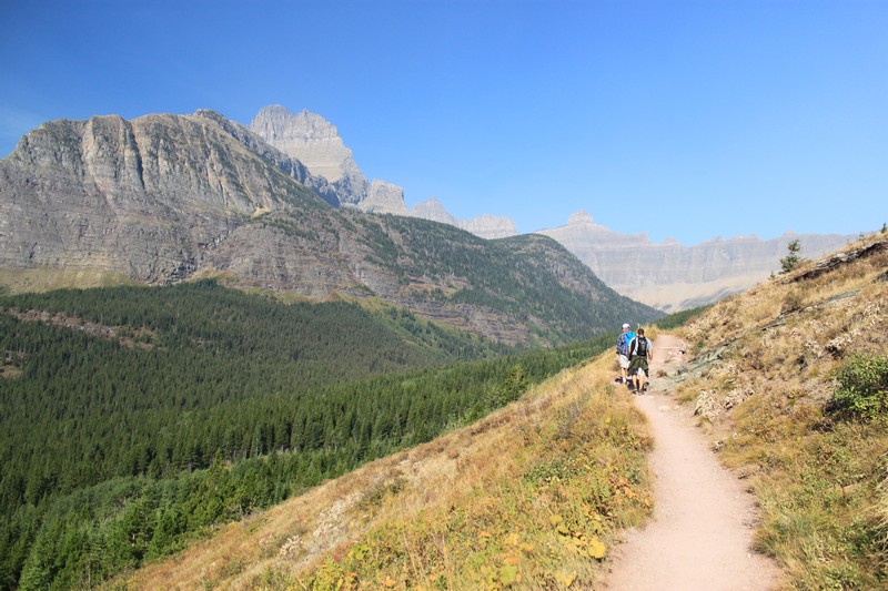
However, in Colorado that stuff is everywhere! The really high peaks are packed with such formations; especially glacial lakes. There are even a few fading bits of actual glaciers on some of the higher mountains. Not many of those are left--and they'll soon be gone, thanks to human-cased global warming--but you can spot what are left beneath some of the very tallest summits of Colorado.

Glacial lake on the Glacier Gorge Trail in Rocky Mountain National Park.

The three amigos at a glacial lake, big peaks surrounding us.
The remains of an old glacier. Now nothing but a melting permanent snowfield. Soon to be not even that.
Looking back down at a glacial lake.

A smaller tarn located below Chasm Lake on Longs Peak in the Rocky Mountain National Park. The falls on the right are the outflow of Chasm Lake.

Chasm Lake. (I was suffering miserably from altitude sickness when I shot this video. I only made it to the lake out of sheer stubbornness.)


One of the most famous glacial lakes, Maroon Lake, with the equally famous Maroon Bells reflected in its surface.

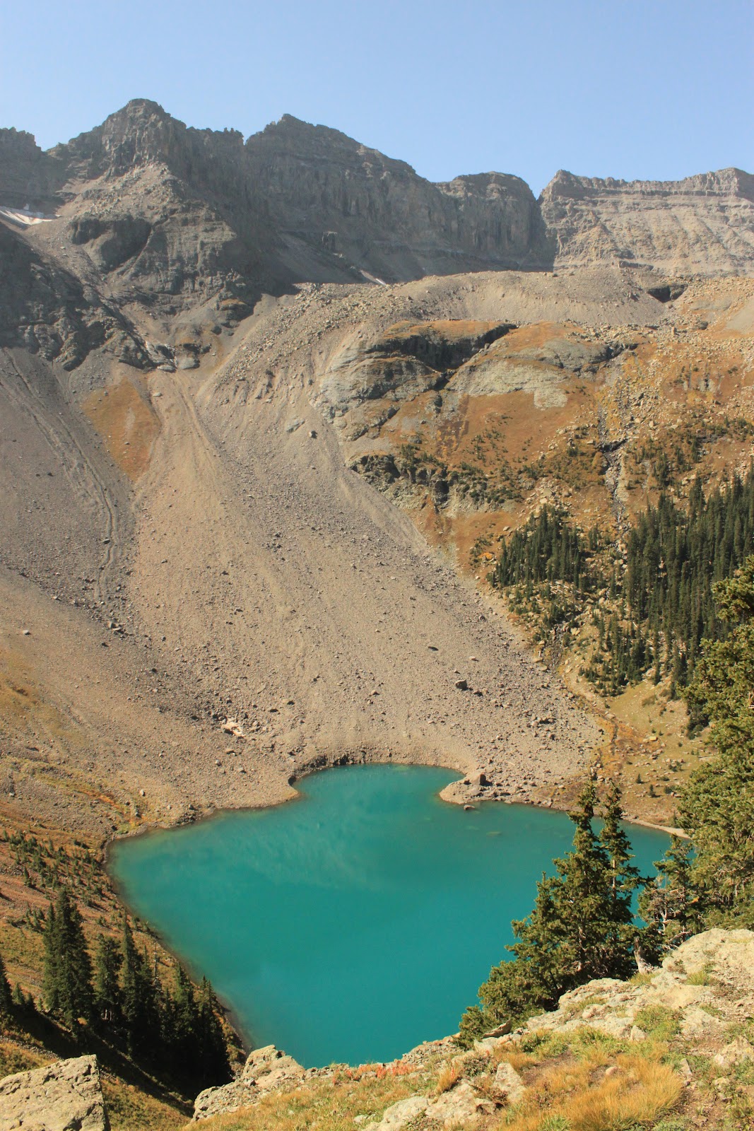
You can even see the old glacial flow pattern leading down to Lower Blue Lake. The lake is still brilliant blue from the suspended clays in the water left by the once-flowing glacier.

Glacial headwall at Upper Blue Lake. This is textbook image of a glacial headwall, where (once upon a colder time) a glacier was birthed at this high point and flowed down the mountain, carving out a big U-shaped valley. When the glacier melted, the valley was revealed, along with pools of water that are now glacial lakes.
Video of the headwall at Upper Blue Lake.

Thursday, December 29, 2011

Boone Bowl, Part Deux

My pal Andy Kunkle, (who has logged about ten jillion more hiking miles than I have), sent me this photo of the Boone Bowl on Grandfather/Tanawha.

Looking at that, I rather do think that it is, indeed, a glacial cirque. I'm wondering where the glacial moraines would be. I don't think it would be difficult to locate them by looking at some topo maps or, perhaps, scouting around points where a terminal moraine would have been located.

If there was a local glacier there, it looks like it was a rather big one. Far wider than some of the other glacial cirques I've seen on eastern mountains.

Bottom line is, I think it really is evidence of a localized glacier that once flowed here in North Carolina!

Photo by Andy Kunkle.