On a very nice November day in 2004, I headed up to Mount Mitchell State Park. I'd intended to arrive at the trailhead for the Black Mountain Crest Trail at around seven am. However, due to delays I got a late start and it was much later that I arrived at the southern terminus of that trail just below the summit of Mitchell. It was my intention to hit every 6,000-foot peak between Mitchell and Winter Star. Since I was looking at a round trip of around twelve miles, I figured that I had more than enough time to complete the hike in the daylight remaining to me. How hard could twelve measly miles be?
 The start of the trail, as it runs past a picnic area near the summit of Mitchell.
 It's even graded as it descends into the gap between Mount Mitchell (highest peak in the eastern USA) and Mount Craig (second highest peak in the eastern USA).
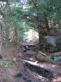
 One begins to get a taste of the rugged terrain on this ridgeline as the summit of Craig draws near.
 The view from the top of Craig as I looked back toward Mount Mitchell, where I had begun the hike. (The tower on the top of Mitchell is gone, now, replaced by a newer design.)
 I was feeling pretty darned good as I took this self-portrait on Craig, looking forward to bagging so many sixers in one day!
 The thing about the Crest Trail is that it tackles the peaks head on. As soon as you hit a summit, the trail takes you directly down into the adjoining gap between peaks. Sometimes you drop about a thousand vertical feet.
 Here's an old slide on the slopes of Potato Hill. I'm told it dates back decades. The forest have yet to heal the wound scoured on the peak by water and gravity.
 And there I was, in Deep Gap (around 5,000 feet), looking up at the last peak that I would bag that day: the uniquely named Winter Star.
 At last! In the middle of a long day of hiking, I stood on the summit of Winter Star, amidst the spruce and beech trees. I was still feeling pretty good, despite the fact that I was realizing that, perhaps, I hadn't brought enough water along.
 More sixers lay beyond--Gibbes, Celo Knob. But they were miles distant, and I'd have to save those for another day.
 I turned around to head back, and for the first time that day I had to wonder if I had enough daylight remaining to get back to my truck before dark.
Continued...


No comments:
Post a Comment